Showing 20 results
Archival description
Illustrated Plan of the City of Sydney, Nova Scotia

Map of New England and Nova Scotia

Nieuwe koart van Terre Neuf en Nieuw Schotland

A Plan of the City and Harbour of Louisburg with inset map of The Island of Cape Breton

A map of the Harbour of Louisburg and parts adjacent

Terra Nova

Grund Riss der Americanischen Insuln Cape Breton, St.Jean und Anticosti im Flusse S.Laurencii

Canada

Carte du Golfe de St-laurent et Pays Voisins.

Carte de L'Acadie Isle Royale, et Pais Voisins. Pour servier a l'Histoire Generale des Voyages

Isle Royale

Le Canada ou Nouvelle France

Carte de L'Isle Royale 1744
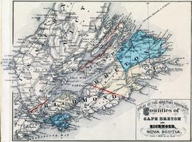
Atlas of the Maritime Provinces - Counties of Cape Breton and Richmond, Nova Scotia
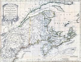
A new map of Nova Scotia and Cape Breton Island with the adjacent parts of New England and Canada

Atlantic Canada

Port de Louisbourg dans l'Isle Royale

A chart of the Island of Cape Breton

Plan of the City & Harbour of LOUISBURG; shewing that part of the GABARUS BAY in which the English landed, also their Encampment during the Siege in 1745

Plan of the City of Sydney