Showing 20 results
Archival description
Terra Nova

Le Canada ou Nouvelle France

Nieuwe koart van Terre Neuf en Nieuw Schotland

Carte de L'Isle Royale 1744

A Plan of the City and Harbour of Louisburg with inset map of The Island of Cape Breton

A map of the Harbour of Louisburg and parts adjacent

Carte du Golfe de St-laurent et Pays Voisins.

Carte de L'Acadie Isle Royale, et Pais Voisins. Pour servier a l'Histoire Generale des Voyages

Map of New England and Nova Scotia

Plan of the City & Harbour of LOUISBURG; shewing that part of the GABARUS BAY in which the English landed, also their Encampment during the Siege in 1745

Canada

Grund Riss der Americanischen Insuln Cape Breton, St.Jean und Anticosti im Flusse S.Laurencii

Isle Royale

Port de Louisbourg dans l'Isle Royale

A chart of the Island of Cape Breton
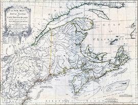
A new map of Nova Scotia and Cape Breton Island with the adjacent parts of New England and Canada

Atlantic Canada
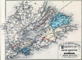
Atlas of the Maritime Provinces - Counties of Cape Breton and Richmond, Nova Scotia

Plan of the City of Sydney

Illustrated Plan of the City of Sydney, Nova Scotia