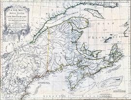
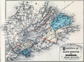
Maps

Elements area

Taxonomy

Code

Scope note(s)

    Source note(s)

      Display note(s)

        Hierarchical terms

        Maps

          Equivalent terms

          Maps

            Associated terms

            Maps

              18 Archival description results for Maps

              18 results directly related Exclude narrower terms
              MAP 667 · Item · 1767

              Item is an original map showing acreage of Cape Breton townships, parishes, and counties. The map identifies "Indian Hunting Country" based on an earlier survey completed by Samuel Holland.

              CA BI MAP 249 · Item · 1747

              Item is a map showing details of Louisbourg Harbour and Gabarus Bay with a full inset map of Cape Breton Island, labelled Isle Royal. Documents the landing place and camp of the New England forces as well as the fortified town of Louisbourg, various battery locations, French settlements and the lighthouse.

              Kitchin, Thomas
              Carte de L'Isle Royale 1744
              CA BI MAP 711 · Item · 1744

              This item is a hand-coloured map of Isle Royale (Cape Breton Island) by Jacques Nicolas Bellin from the Petit Atlas Maritime published in 1764. During the French colonial period, permanent settlement on Isle Royale grew to 4000. This map shows changes in place names reflecting the French and Mi'kmaw presence.

              Bellin, Jacques Nicolas
              Isle Royale
              CA BI MAP 707 · Item · 1764

              Item is an 18th century map of the Gulf of St. Lawrence and Acadie from Bellin's "Petit Atlas Maritime."

              Bellin, Jacques Nicolas
              Little Bras d'or
              CA BI MAP 618 · Item · 1947

              Item is a marine map of Little Bras d'Or.

              CA BI MAP 247 · Item · 1758

              Item is a map of New England and Nova Scotia showing Newfoundland and Cape Breton Island situated in the Gulf of St. Lawrence. The map includes identified fishing banks.

              Kitchin, Thomas
              CA BI MAP 248 · Item · 1703

              Map by engraver Herman Moll showing fishing resources of Newfoundland, Nova Scotia and the Gulf of St. Lawrence during early 18th century. This map depicts shared international fishing banks before the Treaty of Utrecht of 1713 created geo-political boundaries restricting fishing territories.

              Moll, Herman
              Nova Scotia and Cape Breton
              CA BI MAP 199 · Item · 1834

              This item is Belcher's map of Nova Scotia including Cape Breton. The map was compiled from surveys by William MacKay in 1834. Map shows township boundaries and expanding communication and transportation infrastructure including telegraph stations and railway lines.

              Belcher, C.H. and MacKay, William
              Plan of the City of Sydney
              Map 424 · Item · 1910

              Item is a Plan of the City of Sydney with businesses, churches and schools identified on the map with a list of each located on the left side of the map. Along the right side of the map are a list of the advertisers included on the map.

              CA BI MAP 805 · Item · 1764

              This map was originally part of Bellin's "Le Petit Atlas Maritime" showing French fortifications destroyed during the 1758 siege.

              Bellin, Jacques Nicolas